
Sarah M. Morse
Electronic Portfolio
Examples of GIS Work
Click images below to view full-size maps.
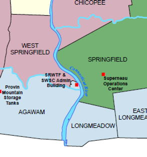
This was created to provide a facilities map for the Commission which schows all facilities, reservoirs, and other Commission owned property.

This map was created to display a new development called Courtside in Springfield, MA. I GPS'd all valves and hydrants in the development, exported the data to GIS and drew in the mains based on my GPS points. The mains lined up perfectly with the city's existing property lines.


The DPW sends out a preliminary paving list yearly. I take the streets on the paving list and create a visual for the Commission and Springfield residents.
Part of a project completed for Hartsville, South Carolina. A map showing the South Hartsville Neighborhood and respective Census Tracts surrounding the neighborhood.

Part of a project completed for Hartsville, South Carolina. A map showing the South Hartsville Neighborhood on an Esri Aerial Image with vacant land depicted in blue.

Part of a project completed for Hartsville, South Carolina. A map showing the South Hartsville Neighborhood on an Esri Aerial Image with various buffers from points of interest in and around the neighborhood.
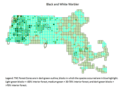
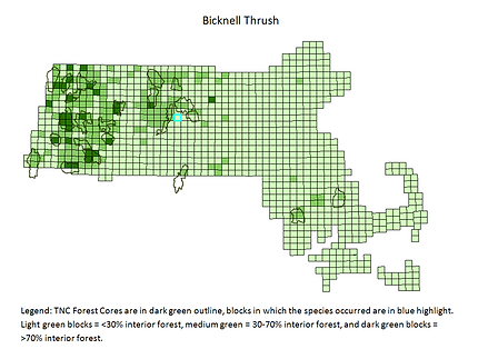
Two out of the 35 bird maps I created for my work with the Nature Conservancy. These maps show where specific species are breeding within the state of Massachusetts using a block layout.

Land Use Map of Millbury, MA comparing land use in 1971, 1985, and 1999.

Map showing the 2005 forest cover of 7 towns within a two mile radius of Shrewsbury, MA.